LODding Terrain for 3D in Godot
No worries !
- Edited
Refactoring. Pls. stand by :-/
Am currently simplifying the conversions between raster space, the space represented by the raster of the spacial data structure which are basically integers for the positions in heightmap textures, and world space, which is the usual floating point stuff one deals with in any 3d application.
Before there was the possibility to extend a terrain in all directions, but that lead to conversion problems I could not really wrap my brain around. Si si, somos aficionados ...
So, in future I will start any quad tree's raster at 0,0,0 and extend it out to max, which is limited to power of 2 sizes. That makes things considerably easier, also when I think of presenting everything to people who probably just want to slab in a bunch of textures and expect it to just work.
Since I also have a new home to build, this may all take a bit longer.
Lesson learnt: Do not say it will be done until it is done.
- Edited
The last overworking got me one step forward. That's from the rim of the canyon where I stood :-)

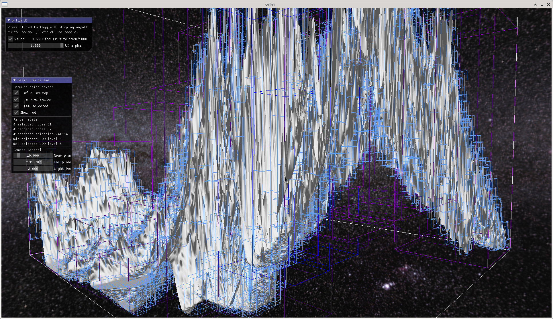
Never mind the flat shading. Shown is one terrain tile made from a 16bit heightmap 4096*4096 pixels, but it works well up to a tile size of the maximum the graphics card can digest. My test data is SRTM (Shuttle Radar Topographic Mission) data, shown is a part of the Himalaya, distance between two posts is about 90m. Purposefully exaggerated to better show the boxes that cover the terrain for view frustum selection.
The white lines are bounding box of the whole tile, the light blue ones are all the boxes of each node of the spatial data structure, the coloured ones are the per frame selected lod levels as seen from camera position.
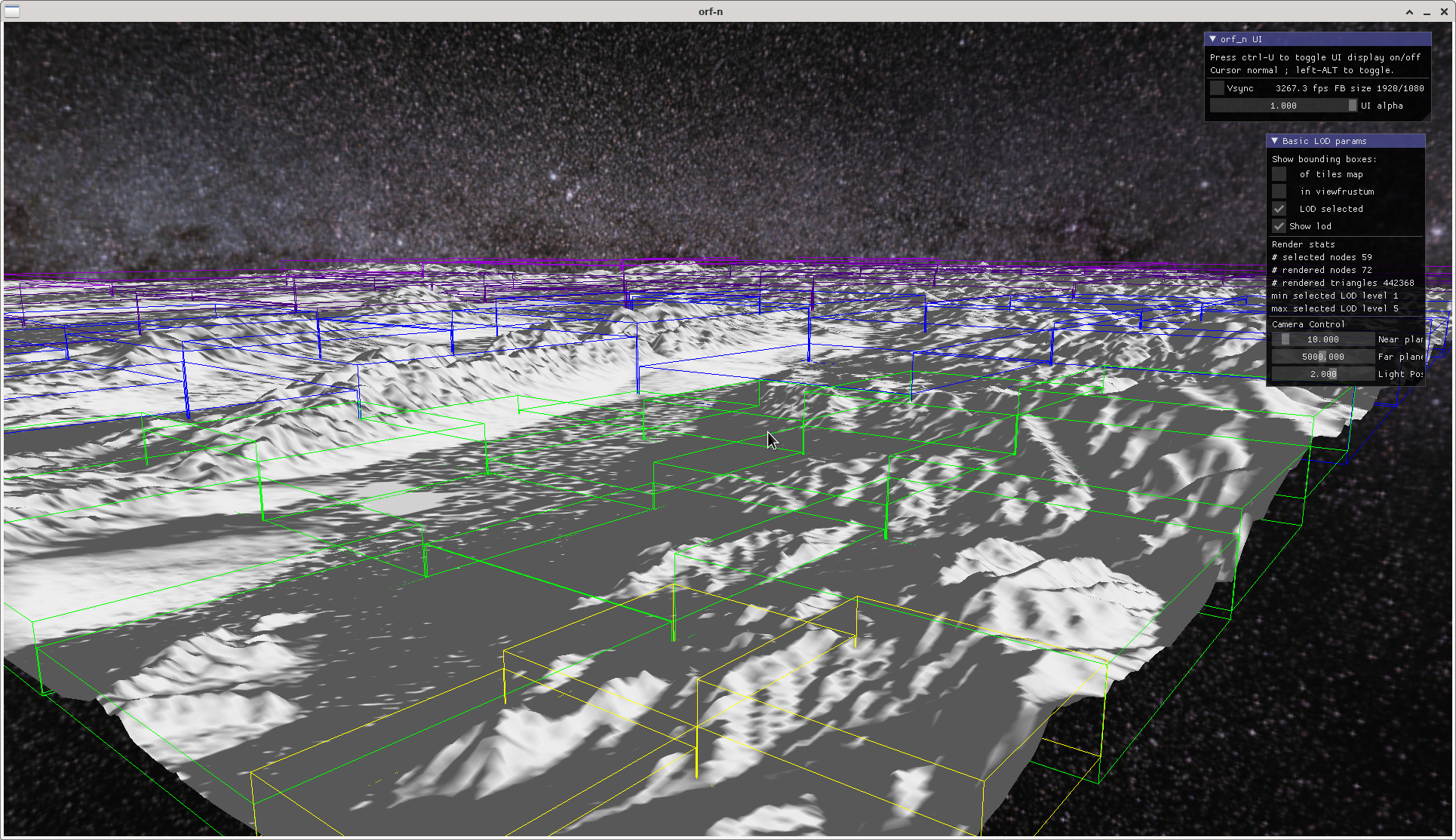
Sending two 0s away gives us:

with the bounding boxes of the lod levels.
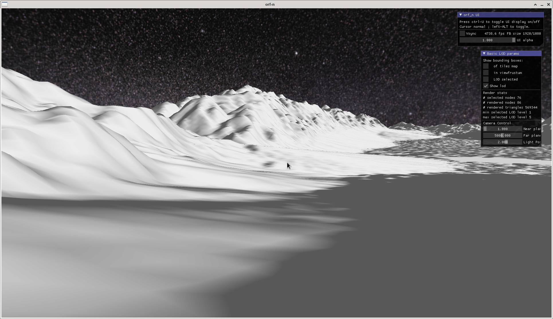
A close-up of a valley gives an impression of what the terrain lod is planned for (no planetary curvature yet, or any sophisticated shading, that's future music for now):

- Edited
So, the base algorithm is finally working.
https://github.com/BaronVerde/cdlod
Tagging @Haystack , whenever you like.
A 4k heightmap texture comes with it. Ask me if you want a 16k texture, or search SRTM 90m data download, select the region you want, choose ARC ASCII as format, and see my other rep srtm-converter for how to generate .png tiles from the SRTM ASCII data. Also, try noise textures you may have somewhere. Eventually tweak the HEIGHT_FACTOR in settings.h.
Loading of a large heightmaps takes a few seconds, though that's going to change. Please mark the b* and krams directories under src as exclude from compile or you get multiple definition errors. These are just backups from working states.
It is only a single heightmap texture for now, and only flat vertex shading. No cosmetics. If you use an own heightmap, make sure it is 16bit-grayscale png of power-of-2, edit RASTER_MIN and MAX values in src/applications/cdlod/settings.h, and add a .bb text-file next to the heightmap texture. Look into src/renderer/renderer.cpp and change the filename there. Don't add .png. Attention, though there is a vector defined there, only one texture is loaded.
Next steps:
Comb the code. There are quite a few implicit conversions I must get rid off. - done -
Texture compression. - scrubbed, using half floats and uint16_t -
Parametrize and correctly calculate raster-to-world sizes and distances. My poor brain ...
Abstract texture types and bit depths and quite generally heightmap sources.
Build a data structure for heightmaps, and load/unload them asynchronously.
Render relative to eye. That means an own terrain camera.
Then: try to get it into the Godot scene tree.
Then proper texturing, rendering, evtl. cascaded shadow maps that fit the lod levels and ranges, collisions, placing of game objects.
Need a beer.
- Edited
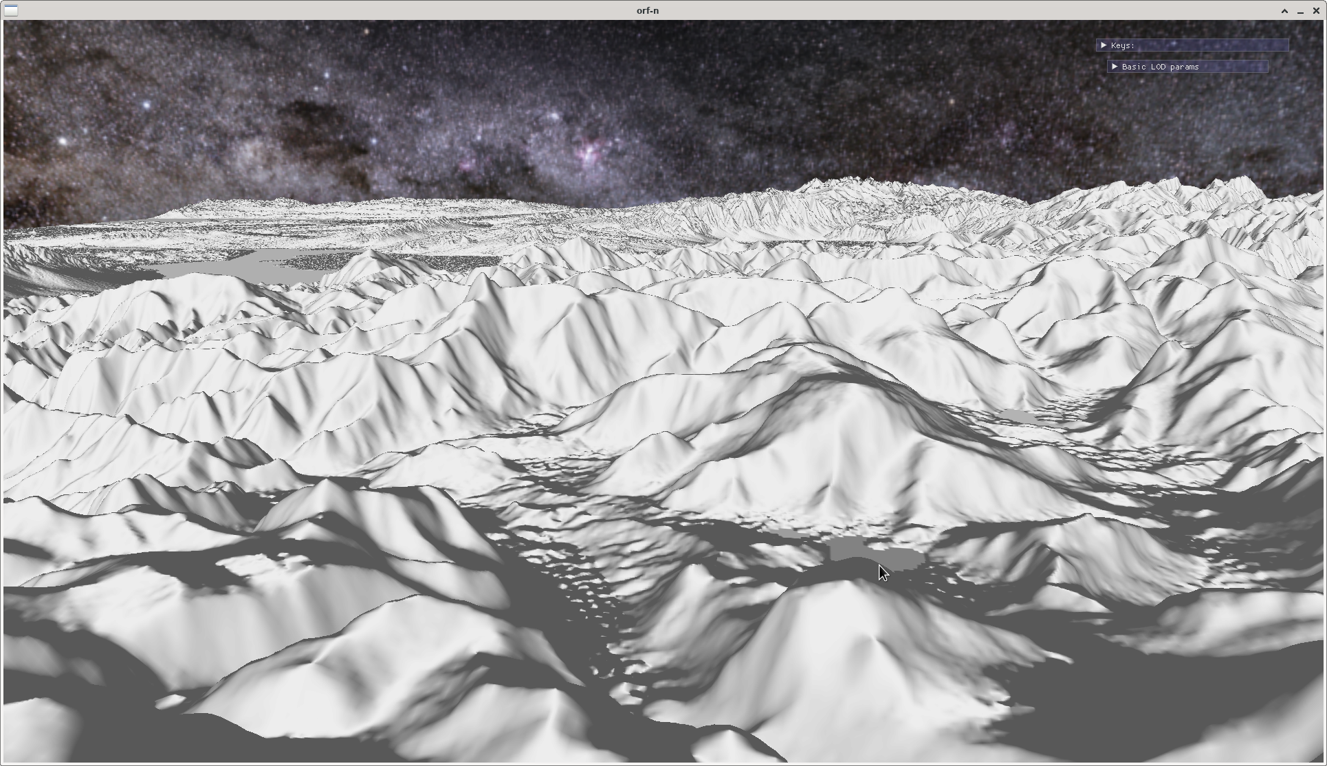
Effect of a resolution multiplier that equally divides the space between two heightmap posts and thus "fakes" a higher resolution than there actually is. It is just a linear interpolation. Considerably improves visual experience (look at the detail in the distance), raises number of triangles rendered, and adversely affects performance :-/

4*resolution multiplier, 11 million triangles per frame, frame rate drop from around 5000/s to 1000/s compared to the other screenshots which are from the same heightmap.
- Edited
Pixophir Considerably improves visual experience ... and adversely affects performance :-/
Look, sometimes it's worth it, ok? 
1ms vs 0.2ms is not a big deal.
Certainly. Specifically comes in handy when using procedurally generated maps from noise or fractals. And there are other methods to control the density in a distance. Otoh, proper shading isn't yet done, nor shadows. So, it will not stay that comfortable.
But of course, having a higher resolution heightmap right from the start would be best. The resolution in the example is also not exactly game-friendly, it is around 90m between posts. A small thorpe or village would just be a speck from that perspective.
Have also experimented with different methods to calculate the normals, which is done on the fly in the vertex shader so I don't have to do normal maps for the terrain. Will offer several methods further down, to control better the "crispyness" of the image.
Huge work.  Unfortunately, all the landscape generators do not take into account the principle of the formation of rivers. Rivers are not just irregularities filled with water. Until hydrodynamics in terrain formation is implemented, even the best generators will only be able to automatically create a lunar landscape. Or require a lot of manual revision.
- Edited
Thanks :-) Yeah, my stuff it just a renderer for heightmap images that stem from elsewhere. I will do an interface that people can use to adapt their own heightmaps.
But there is quite some work on modelling of drainage systems. Look at this, for instance:
https://hal.archives-ouvertes.fr/hal-01339224/document
Update:
OpenGL built-in texture compression for heightmap (RGTC) is scrubbed. Too lossy.
Pixophir But there is quite some work on modelling of drainage systems. Look at this, for instance:
https://hal.archives-ouvertes.fr/hal-01339224/document
This is excellent work! But as far as I understand, it remained at the level of the concept and did not get any practical questioning. And that's too sad.
They have an implementation, they write.
And there's more work out there. I believe Outerra has made something similar. And I have read papers in which they try to mimic plate tectonics. Don't have the time to gather the information again.
Bit I'd say the algorithm in the above paper could be implemented right away.
- Edited
Yes. You can use whatever build system you like or your IDE supports (even Scons  ). I just use the Eclipse-cdt built-in.
I set include paths to the src/ and extern/ subdirectories. All includes should be relative (sometimes Eclipse gets in the way and renames them). Refer to the readme.txt for other dependencies. Link against the dynamic loader and pthread. Well, you'll see :-)
I am not into the make family because they drop their files in every directory.
- Edited
I have something to ponder.
The initial version (that btw.. compiled on Windows with only minor adaptations, thank you @Haystack) was based on a heighmap that is available in its entirety right from the beginning. I got away without any pre-processing of data, just load the texture image and start rendering.
I said I build a data structure of aabbs of given node_size that are used to select what needs to be rendered this frame. For that, I need the horizontal extent which is trivially known by the node's x/z position in the quadtree. And the minimum and maximum height, either thoroughly looked up from all the node's height values which is slow but accurate or estimated for instance from lookups of corner points and centre or any selection of values inside of the node. More formally: a node's aabb at position x, z in the raster of the quadtree has the coordinates
minimum = (x, minimum height of node's area, z)
maximum = (x+node_size-1, maximum height of node's area, z+node_size-1)Savvy so far ? 
I did this to have optimal flexibility, as everything terrain renderer related could be recalculated on the fly.
These days seem to be over when I expand this to something that doesn't fit into memory any more. The quadtree is generated as a whole, but heightmap tiles will be loaded on demand. So he horizontal extent of a node is still there as it only depends on the quadtree, but the node's height values are not yet in memory.
I could
- (a) just ignore them and use an aabb of magical height for the selection.
- (b) pre-calculate minimum and maximum values.
- (c) look them up each frame during node selection.
- (d) insert them into the nodes' aabbs on tile loading.
(a) Not feasible. In steep terrain nodes will be missed.
(b) Possible. Needs a pre-calculation step that extracts minimum and maximum values when the heightmap images are generated. Or I would have to offer a tool. Disadvantage: I loose quite some flexibility as the node size must be known when a heightmap is generated. This means people should know what area and spatial extent a heightmap is meant to be for when they make one.
(c) Possible for small heightmaps, but quickly slows down the algorithm because of cache misses.
(d) Possible, but would probably lead to some popping and actually I wanted to avoid this type of artefact
But it would be slow as I'd have to traverse the tree to find each node and assign the minimum and maximum values. It'll also significantly slows down the loading process for a tile.
Maybe I have not thought of something.
I tend to (b), create a min-max-map and sacrifice flexibility. Creating such a map would be a nice finger exercise for an aspiring C++ newcomer. I'll help :-)
- Edited
IMO, Either b) or d) or if you can afford to implement both, option e) "choose your poison", let the game designer choose which works best for them.
But if only one, keeping in mind that
Pixophir actually I wanted to avoid this type of artefact
I'd also go for b)
- Edited
That would be possible to do both methods, it is not a big deal logic wise, just diligence.
Currently doing a small generator (diamond square) for terrain at higher resolution than I can do with real world data. I need some realistic values suitable for a game environment for testing.


